First, take a look at a screen shot of the Final Display.
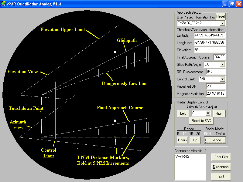
The radar display is drawn on the left hand side, while the information
boxes on the right control information about how the display is drawn, and
how connections to the network (typically the internet) are managed.
The targets on the Final display are drawn with a bright spot
only where the target was at last "hit", and are drawn appropriately
where they would be in relation to the lines referred to on the image above.
It is possible that an aircraft could be visible on the elevation display,
and not in the azimuth display because he may be too far from the Final Approach
Course (FAC) to be drawn there. The Final display interrogates and plots
connected aircraft at 0.5 (one half) second intervals, allowing for
the faster detection time required to provide for approach precision. No
trail history is provided on this display. Over a slow network connection,
you may not be able to get position updates fast enough to provide an approach.
If all else is good, a simple modem should be fast enough. Note the distance
markers from left to right. The spacing varies, with greater spacing on the
left than on the right, providing more precision closer in where it's more
critical.
In the top, right hand side of the program window, you'll see the boxes
defining the Approach Setup. They describe the approach and touchdown
area. You must define at least a few basic characteristics about the runway.
Latitude and longitude of the runway threshold are vital, as is the
elevation above sea level. The latitude and longitude must be presented
in degrees with decimals, not degrees/minutes/seconds. Also, north
latitudes and east longitudes are the positive values, as per international
convention on the topic. For elevation, the value is to be in feet above
sea level (ASL). The Final Approach Course is also vital for describing
the approach. It is the track to be flown, in degrees magnetic, while
approaching the runway. This value may contain decimals for greater accuracy.
Any precision approach will have a glidepath, and the Glidepath Angle (GPA)
is the next spot. There are many preset values, in 0.1° increments set
into the combo box, right up to a very steep 7° slope. I wouldn't expect
that this would get much usage as a standard is a 3° slope. No typed-in
values are accepted. GPI displacement is the distance from the runway
threshold lat/long pair above to where the glidepath will intercept
the touchdown area. It is the Ground Point Intercept of the glidepath.
This variable was added so somebody setting up an approach could use the
runway threshold latitude and longitude, and define the touchdown area as
a distance further along the runway, rather than having to figure out the
touchdown area manually. This value is typically in the neighbourhood of 1,000
feet. If the lat/long placed in the above fields IS the touchdown point desired,
GPI should be set to zero. An example of this would be setting up a touchdown
point based on scenery within Flight Sim, like the third wire on an aircraft
carrier deck. The Control Limit refers to the Radar Control Limit, or the
last point at which ATC can give directions to an aircraft for correcting
his approach. After an aircraft has "passed through radar control limits",
the controller will normally continue giving position information, but unless
safety is a concern, no further corrective instructions will be issued. This
is described in fractions of a mile, ranging from zero to 1NM in eighth mile
increments. The value here determines where the control limit line will be
drawn on the screen. Like the glidepath angle box, only the values in the
drop down list are accepted. One difference here is that the "approaches.ini"
file lists this in a decimal value -- 3/8 mile is denoted as 0.375, 1/2 would
be 0.5, etc. Published decision height is provided for information only,
and does not affect the plotting of anything on the screen. Magnetic variation,
however, does. This value, in degrees with decimals being allowed, provides
the program with the corrective value to make sure straight up on the screen
is magnetic north. One more important point: All decimals in all fields
must have a period instead of a comma to ensure that the value gets converted
properly. This goes for both the "approaches.ini" file and the text boxes
on the Quad Radar screen. A comma will end up truncating the value, turning
"44,64334678234" into "44". This will have the effect of either not seeing
the aircraft, since they will be too far away, or it will help you vector
them to final nowhere near where the runway really is. Every time the display
is plotted, the boxes at right are read. This means the display can be adjusted
on the fly. That is, if the final approach course is a little off, you can
place your cursor in the Final Approach Course box and change the value,
instantly updating the screen. Also, the latitude and longitude of the display
can be changed similarly. Care must be taken to ensure only numerical values
are input, and that they are valid values, or the display will be wrong.
As with the Traffic display, the ranges selectable are only 5, 10,
15, and 20 NM, adjusted by the Range sub-selection in the Radar Display
Control box under the Approach Setup box. Changing the range on the Final
display also changes the range on the Traffic Display. Use the Change
button next to the Range Selection buttons to toggle between the Traffic
and Final displays.
The Connection Manager is last. This is accessible regardless of
which mode the Display is set to. It allows the controller to open and close
the port to the network, meaning you can control the program's willingness
to accept connections. It also shows a list of connected aircraft callsigns,
reminding you who is connected, since you don't have "data tags" on the display
itself. Also, it gives a facility to disconnect individual pilots by clicking
on the callsign to highlight the aircraft's callsign and then clicking on
the "Boot Pilot" button to remove his connection. Note that if a position
report from the pilot's Transponder is delayed by internet traffic and is
received after the boot pilot button was clicked, it may show up as being
connected again, and the pilot may have to be booted again.