vPAR QuadRadar - PAR Display
March 1, 2005
Michael Oxner
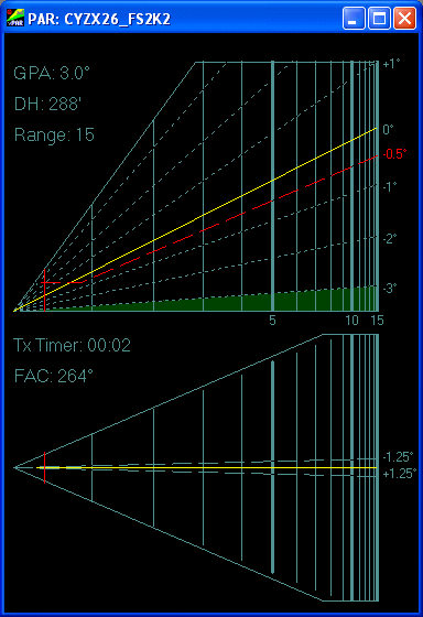 The new PAR screen took some time to evolve, with changes occuring
late in development. In the old one, a logarithmic scale was used for
distances as is generally used in real-world PAR screens. This is demonstrated
in the image at left. This means that the number of pixels between one mile
marker on the left hand side of the screen, closer to the radar origin,
is greater than the number of pixels between mile markers on the right.
This allows the controller to get better resolution close-in on short final
than is required while a long distance from the runway at higher, safer
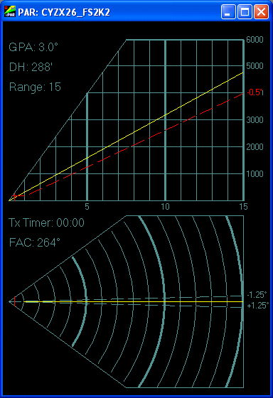
altitudes. Another mode is now available in vPAR: A linear scale. This will
give the controller a uniform presentation of speed and distance throughout
the approach. Also, in linear mode the elevation display (top half of the
screen) gives an indication of altitude now. An image of the linear mode
is provided below. This altitude is calculated from radar returns, not from
Mode C readout. If the pilot has his altimeter set wrong, you'll notice
he's not at his assigned altitude. Note that this altitude is height
above the touchdown area, not above sea level. If your airport is at
500' ASL, an aircraft indicating 2,000' on the Traffic display will show
1,500' here. The aircraft's Mode C readouts are not shown for that reason.
This sort of gives a look at the remaining mode of a Quad Radar that is
not directly modeled, the Height Finder. The background line color can be
changed in the PAR Setup Dialog, as can the target color. The Glidepath
now shows up in yellow, and the red line indicates the Low Altitude
Warning line. At this point, control action could include instructions
to level off or go-around. This line is drawn below the set glidepath by
an amount that is user-changeable in the PAR Setup dialog detailed below.
Where the LAW line meets Decision Height, the red dashed line levels off.
The GlidePath Angle and Decision Height values are provided here for controller
reference, as this information must be given to the pilot before commencing
descent. Version 2.0 of vPAR introduced a few more items in the display.
First off, the Glidepath is now in a constant position, regardless of
Glidepath Angle for both the Linear and Logarithmic plotting modes. The
elevation view represents a field of view of 7° in the vertical, 3.5°
above and below the Glidepath. The image at left shows a 3° GPA, which
means the horizon will be visible. Notice the subtle dark green shading in
the bottom? That's the horizon. In the logarithmic mode, changing to a lower
GPA will make the horizon rise, and making it a higher GPA will make this
fall off. A GPA above 3.5° will leave the horizon below the horizontal
line, and therefore the horizon will not be visible in the display. Additionally,
the degree values are shown relative to the GPA at right. In the Linear mode,
the height and spacing of the lines will vary depending on range and GPA.
The altitudes are drawn on the right hand side as well, to let you know where
an aircraft is, rather than having to do the math on the line spacing yourself.
The interval between horizontal lines changes with GPA.
The new PAR screen took some time to evolve, with changes occuring
late in development. In the old one, a logarithmic scale was used for
distances as is generally used in real-world PAR screens. This is demonstrated
in the image at left. This means that the number of pixels between one mile
marker on the left hand side of the screen, closer to the radar origin,
is greater than the number of pixels between mile markers on the right.
This allows the controller to get better resolution close-in on short final
than is required while a long distance from the runway at higher, safer
altitudes. Another mode is now available in vPAR: A linear scale. This will
give the controller a uniform presentation of speed and distance throughout
the approach. Also, in linear mode the elevation display (top half of the
screen) gives an indication of altitude now. An image of the linear mode
is provided below. This altitude is calculated from radar returns, not from
Mode C readout. If the pilot has his altimeter set wrong, you'll notice
he's not at his assigned altitude. Note that this altitude is height
above the touchdown area, not above sea level. If your airport is at
500' ASL, an aircraft indicating 2,000' on the Traffic display will show
1,500' here. The aircraft's Mode C readouts are not shown for that reason.
This sort of gives a look at the remaining mode of a Quad Radar that is
not directly modeled, the Height Finder. The background line color can be
changed in the PAR Setup Dialog, as can the target color. The Glidepath
now shows up in yellow, and the red line indicates the Low Altitude
Warning line. At this point, control action could include instructions
to level off or go-around. This line is drawn below the set glidepath by
an amount that is user-changeable in the PAR Setup dialog detailed below.
Where the LAW line meets Decision Height, the red dashed line levels off.
The GlidePath Angle and Decision Height values are provided here for controller
reference, as this information must be given to the pilot before commencing
descent. Version 2.0 of vPAR introduced a few more items in the display.
First off, the Glidepath is now in a constant position, regardless of
Glidepath Angle for both the Linear and Logarithmic plotting modes. The
elevation view represents a field of view of 7° in the vertical, 3.5°
above and below the Glidepath. The image at left shows a 3° GPA, which
means the horizon will be visible. Notice the subtle dark green shading in
the bottom? That's the horizon. In the logarithmic mode, changing to a lower
GPA will make the horizon rise, and making it a higher GPA will make this
fall off. A GPA above 3.5° will leave the horizon below the horizontal
line, and therefore the horizon will not be visible in the display. Additionally,
the degree values are shown relative to the GPA at right. In the Linear mode,
the height and spacing of the lines will vary depending on range and GPA.
The altitudes are drawn on the right hand side as well, to let you know where
an aircraft is, rather than having to do the math on the line spacing yourself.
The interval between horizontal lines changes with GPA.
In the azimuth presentation, we have distance lines across the entire
display, showing range from the touchdown area. There are a couple of
dashed lines showing 1.25° either side of the final approach
course. Again, the logarithmic and linear scales are available. Whatever
scale you select will affect the drawing of both the elevation and azimuth
screens. You can't select linear for one and logarithmic for the other.
The Final Approach Course line is highlighted in yellow. For controller
reference, two pieces of data are shown here, as well. The first is the
Transmit Timer. This feature is meant to be set up to reset every time you
transmit with Roger Wilco or AVC. The PAR Setup Dialog contains a box for
telling vPAR which key you use for Push-To-Talk with RW or AVC. Each time
you transmit, this timer is reset. This is meant to remind you how long it
has been since you talked to an aircraft while vectoring to final or while
on final, since you have to keep talking to let the pilot confirm he is
still receiving you. Part of a normal GCA is for the pilot to execute a
missed approach and contact another agency if no communication is heard
within a given time period. The numbers in this display turn yellow after
5 seconds (the normal maximum interval between transmissions while an aircraft
is on final), and red after 30 (the normal interval while an aircraft is
on Traffic being vectored to final). The counter will count up to 59 minutes
and 59 seconds before "rolling over" to 00:00 again. The second detail
is simply the Final Approach Course, taken directly from the PAR Setup Dialog,
and rounded off to exclude decimals.
 Both the top and bottom portions of the display will resize when
changing the size of the PAR display. The elevation display information
will remain constant, as the distance and altitude markers will demonstrate.
The azimuth section (bottom portion) will react differently. If you scrunch
the window from left to right, making it very tall and thin, the 5 sided
shape at the bottom will now still reflect the selected range (5, 10,
15 or 20 NM) from the point on the left(the touchdown area) and the veritcal
line on the right. The dimensions from the top to the bottom (the distances
displayed from left of the final approach course to the right of the course),
however, will vary. It could end up displaying a very wide area out on
the final approach course. Conversely, if you were to flatten the window
making it very wide and short, the range will still be the selected range
from the touchdown area to the maximum extent on the right, but the displayed
area left and right of the final approach course will be very narrow.
To more clearly demonstrate this idea, there is a display option, on by
default, on the Traffic display that draws the area covered by the azimuth
area of the PAR display. Try resizing the PAR window with the Traffic window
in view and you'll see what I mean. You can determine for yourself just how
you want to use this. The shape drawn on the Traffic screen will be different
on the linear and logarithmic modes, because of the geometry of the polygon
of the azimuth screen in the two different modes.
Both the top and bottom portions of the display will resize when
changing the size of the PAR display. The elevation display information
will remain constant, as the distance and altitude markers will demonstrate.
The azimuth section (bottom portion) will react differently. If you scrunch
the window from left to right, making it very tall and thin, the 5 sided
shape at the bottom will now still reflect the selected range (5, 10,
15 or 20 NM) from the point on the left(the touchdown area) and the veritcal
line on the right. The dimensions from the top to the bottom (the distances
displayed from left of the final approach course to the right of the course),
however, will vary. It could end up displaying a very wide area out on
the final approach course. Conversely, if you were to flatten the window
making it very wide and short, the range will still be the selected range
from the touchdown area to the maximum extent on the right, but the displayed
area left and right of the final approach course will be very narrow.
To more clearly demonstrate this idea, there is a display option, on by
default, on the Traffic display that draws the area covered by the azimuth
area of the PAR display. Try resizing the PAR window with the Traffic window
in view and you'll see what I mean. You can determine for yourself just how
you want to use this. The shape drawn on the Traffic screen will be different
on the linear and logarithmic modes, because of the geometry of the polygon
of the azimuth screen in the two different modes.
To change range, the most likely action once you have it all set
up, use <F3> and <F4> keys, or the menu items in the
Display menu. Available ranges for PAR display are 5, 10, 15 and 20 NM.
Some mile markers will have a number underneath them on the elevation view.
On the 15 and 20 NM ranges, 5 NM increments are displayed. On the 10 NM
range, each line is marked on the Linear Scale, while 1 to 5 are marked
along with 10 on the Logarithmic Scale. Each mile is marked on the 5 NM
range on both plot modes. Ranges are calculated from the touchdown area
of the runway selected, rather than the radar site or the runway threshold.
So an aircraft on the 1 NM mark is actually 1 NM from touchdown. The touchdown
area is calculated based on the latitude and longitude of the runway threshold
and the Ground Point Intercept value for the approach. The title bar
of the PAR Display will show the currently selected approach as set in
the PAR Setup window.
Also new is the ability to adjust the Final Approach Course and the Glidepath
Angle without having to enter PAR Setup or recreate another approach.
Accessible by menu item in the Display menu and associated keyboard shourtcuts,
you can adjust, or "servo", the FAC in increments of 10°, 1°,
or 0.1° left or right. These shortcuts are various combinations
of <CTRL>, <SHIFT> and the Left and Right Arrow
keys. The FAC indication will change as well, but it will not reflect
the minor changes associated with the 0.1° increment until it
reaches another full degree. Servoing the Glidepath Angle is also available
by keyboard shortcuts, the <CTRL> or <SHIFT> keys
plus the Up and Down Arrow keys. You can increase or decrease the
angle by 0.1° or 1.0° increments. To return to the defaults
for the approach you have loaded, press <CTRL>+<HOME>.
PAR Setup
 The PAR Setup screen is much the same as the old approach setup
area of the old version. All the vitals of a particular approach are displayed
on the left side: Lat and Lon of the runway threshold, Touchdown
Zone Elevation, Final Approach Course(in degrees magnetic),
Glide Path Angle(from drop-down list), Glide Path Intercept
displacement (in feet from the Lat/Lon above along the FAC), Control
Limit in NM, Published Decision Height, and the Magnetic
Variation at the touchdown area. The Traffic and ASDE displays are
corrected with this value as well as the PAR display, so make sure this
is in there. The value must be in degrees with West being Positive.
This setup screen allows you to load values from a saved file, in a specific
format, or to make or modify an approach on the fly. Changes made here
will be reflected in the display at the next update, at the most a half
a second away. As with the first version of of these PAR programs, you have
the option of restoring data from the selected approach in the
drop-down list at the top if you make changes. The PAR Display's
title bar will reflect the name of the currently selected approach,
whether or not you have made changes to the approach selected in the
drop-down list.
The PAR Setup screen is much the same as the old approach setup
area of the old version. All the vitals of a particular approach are displayed
on the left side: Lat and Lon of the runway threshold, Touchdown
Zone Elevation, Final Approach Course(in degrees magnetic),
Glide Path Angle(from drop-down list), Glide Path Intercept
displacement (in feet from the Lat/Lon above along the FAC), Control
Limit in NM, Published Decision Height, and the Magnetic
Variation at the touchdown area. The Traffic and ASDE displays are
corrected with this value as well as the PAR display, so make sure this
is in there. The value must be in degrees with West being Positive.
This setup screen allows you to load values from a saved file, in a specific
format, or to make or modify an approach on the fly. Changes made here
will be reflected in the display at the next update, at the most a half
a second away. As with the first version of of these PAR programs, you have
the option of restoring data from the selected approach in the
drop-down list at the top if you make changes. The PAR Display's
title bar will reflect the name of the currently selected approach,
whether or not you have made changes to the approach selected in the
drop-down list.
Additionally, the first program version required you to shut down the
program if you made changes to the "Approaches.ini" file and wanted to use
them right away. If you were the one setting up an approach, or a number
of them, this could become quite a pain. The "Reload Approaches"
button now allows you to reload the "Approaches.ini" file without restarting
the program.
Under that feature is the Push-To-Talk key box. Place your cursor
in this box and press the key you have assigned to PTT in Roger Wilco
or AVC. The key code will appear there. 17 is the key code for <CTRL>
key and this is what I included as a default. You don't have to know the
key's code, just enter the box and press the key you want to use.
This will be saved when you shut down vPAR.
New to the PAR display in vPAR is the availability of trail dots.
This is set by the "spinner" below the PTT key. Selectable values range
from 0, meaning no trail, to 10 dots. A new trail dot will be placed with
every 5th update received, with the updates being requested through the
Transponder every half second.
Directly across from the Glidepath Angle selection box is the Low Altitude
Warning line angle. It is simply the angle below the glidepath
you want this line drawn. Normally, it's half a degree below, but you
can set what you want. Preset values of 0, 0.25, 0.5, 0.75 and 1.0 degrees
are in the drop-down box. Setting a glidepath of 3.0° with a LAW line
set at 0.5° means the LAW line will be drawn at 2.5° above the
horizon.
The next item is the drop down list of items whose colors can be changed.
Using a standard Windows Color Selection Dialog, you can alter the colors
of the lines and the targets in the PAR display as well
as the trail history. Currently, those are all that you are allowed
to change. Future revisions may include more if feedback suggests strong
desires and time permits. Simply select the item whose color you wish to
change and then click the Select Color button underneath to open the color
dialog and select a color. When you press OK in the color dialog, the selected
feature's color will be changed. There is no "undo" for this function.
The last section on the PAR Setup is the Range Plotting Mode selector.
As mentioned earlier and shown in the images above, linear and logarithmic
modes are available. The logarithmic mode is more true to life than the
linear, but with so many people asking about it, I added it. Simply select
one mode or the other here. This is also selectable through the
use of the Display menu item, which has the keyboard shortcut of <CTRL>+<L>
to toggle back and forth.
All these changes take effect immediately. Simply click the "Close"
button to close the dialog and return to vPAR.